When talking about driverlessness, we are not talking about an independent individual, but a complete technical matrix. In this technical matrix, in addition to radar sensors and algorithms, there is a technology we are very familiar with - GPS. Its existence ensures that the driverless car is driving on the road that should be driven, rather than being around like a headless fly. Let's take a look at the related content with Xiaobian.
We are almost familiar with GPS, and almost started with the phone, this feature began to accompany us. But to a certain extent, we are very strange to this technology, except that it knows that GPS is used for real-time positioning, and it knows nothing about its principle.
The full name of GPS is Global PosiTIoning System - the global satellite positioning system, the technology that exists in everyone's mobile phone, actually from the US military. In the 1950s and 1960s, the US Department of Defense developed a positioning system based on satellite networks based on the positioning requirements of the sea, land and air force. At the end of the Cold War, 24 satellites were launched, and GPS was officially put into use. At the end of the Cold War, GPS began to be put into the civilian market, forming a monopoly trend almost everywhere in the world.
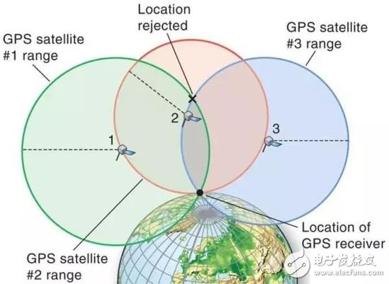
From a technical point of view, GPS uses a triangulation method. Because the position of the satellite in orbit is fixed, the GPS receiver is located on the ground, and the signal is transmitted to the satellite in the air. The distance is calculated by the time of signal arrival and return, and a distance is obtained. The distance is the diameter and the satellite position is the center of the circle. The intersection of the curve and the Earth is where the GPS receiver is located.
GPS that you don't know is more dangerous than you think.
When I saw this, I felt a little shocked. I used to follow me every day and know that all my secret systems came from the US military.
In fact, for GPS, or positioning information, we should have more vigilance.
First of all, it is because a large number of terminals collect and upload our location information when it is not necessary. To understand this, just look at how many geographically unrelated products are sent to the user when they install the app. Once authorized, it is difficult to guarantee that these products will not abuse their power. For example, Uber had a scandal last year, when users found themselves ending their service, Uber will continue to track their position for up to five minutes. Uber even arbitrarily acknowledged this and claimed that he was trying to optimize the details of the space to provide better service (it must be said that Uber's rogue attitude is not the most disgusting technology company in American corporate culture).

(the trajectory around the Pentagon)
Not only mobile apps, but also a lot of smart hardware is also collecting our location information. If you don't read the manual carefully, you won't find it. The most typical one is the "smart bracelet military leak" incident at the end of last year. A GPS tracking company that serves smart sports bracelets such as Fitbit and Jawbone has released a global thermal tracking map to show the running of users wearing bracelets. route. Unexpectedly, the US military distributed a sports bracelet to many soldiers. These bracelets honestly recorded the movements of soldiers and even patrols, and honestly displayed them to the world through thermal tracking maps.
In addition to collecting information, GPS information can be easily forged. Remember the "PokemonGo" of the previous two years? This game is built on the LBS system. Users want to capture the elves, and they need to find the real maps. This is the original intention of the game designer. The people at home walked out of the house.

As a result, the ultimate dead house has designed a way to falsify the GPS signal: the value of the GPS satellite signal received at a certain point at a certain time is calculated by the tool, and then transmitted by the software radio signal transmitter, so that it can be housed at home. Capture the elves from heaven. The whole cost is only a few hundred dollars, and if you are willing to pay for more powerful signal transmitting equipment, you can achieve more powerful effects.
Unmanned out of control future
There may be a lot of people who think here, what do these have to do with us?
Indeed, in many cases we do need to get some personal privacy to get more services. We should also believe that those companies that provide services to us will not easily use our location information in bad places.
However, it is difficult to ensure that no third party will join in and infringe on your privacy in a variety of postures. For example, online search for a real-time mobile phone location search service can be found. The service provider can generate an article link or a corporate red envelope to add location request information. If the red envelope and the link agree to the location request, the service provider The information obtained will be sent to the customer who purchased the service. The people who got the information throughout the process were completely unaware of it.

Can we imagine who is buying this service?
Couples who don’t trust each other, parents who want to control their children, and followers are maddening.
And this is only the impact on individuals in the existing application of GPS technology. When the country is running a GPS-equipped driverless car in the future, what will happen under extreme circumstances? If you stop the service for half an hour, you may let A country's unmanned bus service is shut down; a false signal can lead to fatal traffic disasters in countless places.
The emergence of driverlessness has made the potential danger of GPS for special groups (political military) a ubiquitous danger for everyone.
Big country heavyweight: Why do everyone want their own GPS?
The only way to solve this danger is to build your own satellite navigation and positioning system, even if the project is costly and manpower, even if you use the US GPS, there is almost no cost.
So China launched the Beidou system, Russia launched GLONASS, and the European Union launched Galileo. At present, our Beidou satellite navigation system has launched 29 satellites and is expected to serve global users by 2020. The entire development process has already taken the lead in front of GLONASS and Galileo.
Although many mobile phones are now compatible with GPS and Beidou two navigation and positioning systems, it is frankly in the civilian market, perhaps we will use GPS for a long time. However, the emergence of Beidou can guarantee that our traffic will not be chaotic due to satellite navigation and positioning problems during the war, and vehicles and ships are still heading in the right direction.
It can even be said that the gradual maturity of the Beidou system is one of the major preconditions for the popularity of unmanned driving in China. We should be glad that China's satellite navigation and positioning technology and the world's unmanned technology can be synchronized, otherwise it is to hand over their own lifeline to others. In the 1999 India-Pakistan War, the United States directly shut down all GPS services in the India-Pakistan region, causing huge losses to India. Since then, India has set about creating its own regional navigation system.
This is also a threat that every big country may experience. The development of science and technology must be related to the "device". If the device is mastered by others, the result must be its own skill in the development of science and technology. The unmanned technology seems to be considering sensors and machine learning, and it is actually constrained by the mature technology of satellite navigation.
As for the previous questions, such as whether the Beidou system will be authorized by the background software to read personal information, can you tamper with the signal on individual terminals. At present, it seems that the problems occurring on these GPSs cannot be avoided in other satellite navigation and positioning systems. At present, the best solution is to always pay attention to the background authorization situation, carefully read the manual of each smart product, and improve your vigilance.
AC (Alternating Current) Power cord is to transmit high voltage. It is used to drive machinery or home appliances. Since AC Power Cord is output of high voltage electric power, there is a risk of electric shock injury, therefore, All the AC power cord must comply with safety standard to produce. DC (direct Current) power cord is used to the applicance with lower voltage mostly, so safety requirement is less stringent.
Power Cable, battery cable, DC power cable, AC power cable, power cord
ETOP WIREHARNESS LIMITED , https://www.oemmoldedcables.com